The Fog Is Clearing
New research fine-tunes our
understanding
of a signature Bay
Area spectacle
News article from the  on June12, 2000
News article from the on June12, 2000
|
The curtain is rising for the biggest show in town. It's being staged in the biggest theater -- the total land, water and sky of the Bay Area. This is the season of summer fog, an atmospheric spectacle unique on the planet. On a summer afternoon, look west from downtown San Francisco up Market Street and you may see the fog overtopping Twin Peaks and cascading down the near slopes like a slow-motion Niagara. When conditions are right, you may see a dramatic fogfall at the north end of the Golden Gate Bridge, descending on the traffic along the highway approach. In late afternoon, a wave 1,000 feet high may loom over Sausalito like an ocean comber about to break, back-lighted by the lowering sun. From any of the heights in the city or around the bay, you may sometimes look down on a sea of billowing fog moving in from the ocean, filling the valleys and isolating peaks and ridges into islands in a white flood. ORIGINAL THEORYThe traditional explanation for these extraordinary phenomena-- as characteristic of San Francisco as sourdough and cable cars -- was relatively simple, although the causes are actually far more complicated. The story begins with ancient shifts in the seismic plates of the Earth's crust, which heaved up the western edge of the continent into a mountain wall. That wall is breached by the gateway where the Pacific invades the western edge of North America at San Francisco Bay. Here the oceanic weather regime merges with continental air masses, giving birth to fantastic flowing forms of aerial moisture that visibly evolve with the time of day, the slant of sunlight and the advance of the season. The original theory, still partly valid, went like this: In California's 500-mile-long Central Valley, the summer sun heats the air, which rises and is replaced at the surface by cool ocean air drawn inland through the Golden Gate, across San Francisco Bay and through the Carquinez Strait to the valley. In addition to the pull from the valley, the marine air is pushed by the Pacific High, a mountain of heavy air over the ocean 1,000 miles or more offshore. Around it circulate winds that approach California from the northwest. That incoming sea air is likely to contain fog: The wind from the ocean, blowing down California's slanting coastline, pushes the ocean surface southward. Owing to the rotation of the Earth, the sun-warmed surface water tends to veer offshore, causing an upwelling of colder water from the sunless depths. That icy brine from the sea bottom refrigerates the ocean air and condenses its moisture into visible form, creating the great fog bank that hangs intermittently along the Northern California coast most of the summer. Drawn inland by the valley heat, the cool marine air with its fog flows through the Golden Gate, then south down the bay and northeast toward Carquinez Strait and the valley. Although the fog may evaporate before it reaches the valley, the wind that brings it continues inland and after a few days cools off Sacramento and Stockton, much as a draft from an open door lowers the temperature in a warm room. In the valley the mercury may drop from above 100 into the 80s. Without the intense valley heat to draw the ocean air eastward across the bay, the wind and fog diminish and disappear. The coastline and San Francisco enjoy clear weather, which continues for a few days until the valley heats up again, once more attracting the wind and fog. Three or four days of fog are succeeded by three or four days of sun, completing a weekly cycle that continues through the summer. Theoretically. The trouble with this traditional explanation is that the cycles often fail to work the way they are supposed to. Foggy or sunny spells in the city sometimes continue for weeks, and the periods of fog do not always coordinate with high temperatures in Sacramento and Stockton. NEW RESEARCHThe reasons for such departures were discovered as the science of meteorology made quantum leaps forward. Satellite observations, greater knowledge of ocean currents and new techniques of computer modeling have demonstrated that although the fog penetration is related to the alternate heating and cooling of the valley, it is also influenced by much larger forces in the global weather picture.``The old explanation was simplistic,'' says meteorolgist Jan Null of San Francisco State University, ``because it only dealt with pressure patterns on the surface. But the fog regime is also influenced in many ways by weather systems in the upper air.'' Chief among these high-level systems is the jet stream, a raging river of air 30,000 feet above sea level that continually flows from west to east around the globe, over the Pacific and across the northern reaches of this continent at speeds that can exceed 150 miles per hour. The jet stream is also known as the ``storm track;'' it carries with it the storms that bring rain and snow to North America. Its route depends on the season. In the summer it usually centers over Canada, moving in an unpredictable weaving pattern and bringing rain to a wide swath of the continent, often drenching Vancouver, Seattle and Portland. RIDGES AND TROUGHSAlthough California is usually far south of the summer rainfall pattern, the influence of the jet stream is felt even here. Associated with the jet stream are recurrent waves of high-altitude pressure changes. North-south ``ridges'' (high pressure) and ``troughs'' (low pressure) advance from west to east, much like successive crests and troughs of waves on the ocean. Although the ridges and troughs are high in the sky, they still have an effect on pressures at the surface, including the Pacific High.Ridges bring clear weather to the Canadian coast; troughs come with storms there. A trough bringing rain to Canada and the Northwest will tend to bring fog to the Bay Area. Here's an example of the way it works: A high-pressure ridge developing clear weather over western Canada will also tend to produce blue skies here. Behind it, in the west-east procession, is a trough 1,000 miles or so west of San Francisco. Its low pressure weakens the Pacific High, which slackens the winds sent to the California coast. As a result, the upwelling of cold water from the sea bottom diminishes and the fog-making process slows to a halt, leaving clear weather around the bay. As the entire ridge-and-trough system continues eastward, the trough over the ocean moves to the coast. Replacing it at sea is a ridge that strengthens the Pacific High, which again sends out winds that resume the upwelling and the creation of the coastal fog. Simultaneously the ridge over California moves east, replaced by the trough from the ocean. The low pressure of the trough reinforces the heat-generated low over the Central Valley, again attracting the cool marine air and its fog. In this way the ridge-and-trough pattern strengthens or weakens the weekly cycle that results from the heating and cooling of the valley. It also accounts for the interruption of the weekly cycles by spells of sun or fog persisting for much longer periods. STALLS IN THE CYCLEAt times the successive west-to-east waves of high and low pressure, unlike waves on the ocean, will slow to a stop, due in part to changes in the temperature of the ocean surface. A ridge or a trough may remain over the entire Pacific Coast for weeks, resulting in the extended spells of clear or foggy weather around the bay. Long periods of trough-induced rain in Seattle, for example, will usually coincide with persistent fogs here produced by the weaker southern extension of the same trough, to the frustration of residents of both regions.This year, a persistent trough camped over the coast for much of May, bringing fog, clouds and some late rain here. Then, at the end of the month it moved on east and was followed by a ridge with warm summery days into June. Last week, that ridge in turn moved east and a new trough rolling in from the west brought fog and rain again. There may also be some long-term influences on fog formation associated with global weather patterns, such as El Nino and La Nina. But aside from these unpredictable influences and the occasional pauses in the eastward movement of the ridges and troughs, an approximate weekly cycle still prevails. There are other cycles as well, including one that takes place daily when the fog moves in from the coast late in the day as the sun's radiation weakens. The blanket of moisture spreads over the region during the night, sometimes as far as Sacramento and Stockton, then is burned off by the morning sun. SEASONAL INFLUENCESThe daily and weekly cycles are complicated by the seasonal cycle, which begins with the first tentative wreaths of fog along the coastal hills in early spring, reaches a foggy maximum in late July and early August and tapers off in September and October, the warmest months of the year in San Francisco.In the fall, when the sunlight weakens and the valley heat diminishes, the ocean winds die down and the fog comes in lower and more slowly. This is often the optimum time of year for some of the special effects. Drivers on the Golden Gate Bridge can sometimes look down on top of a white vapory tide, which may continue eastward and billow up over Alcatraz and Angel Island, creating fog domes. THE SPECTACLE CLOSESAt this quiet season, sometimes extending into November, the cascades and fogfalls over the coastal hills of Marin and the Peninsula are most pronounced, and long fingers of visible vapor flow through the gaps and canyons as if sea level were rising and flooding the land. Then as the jet stream with its storms moves south with the season, it brings the first rain, and the Bay Area's spectacular summer comes to an end.
FOG GAPS AND BARRIERS San Francisco Bay is the only sea-level break
in the California Coast Range, permitting the coastal fog to
move entirely through and into the Central Valley. It moves
not only through the Golden Gate and Carquinez Strait, the biggest
gaps in the range, but through some low-level canyons and passes
such as those indicated below. 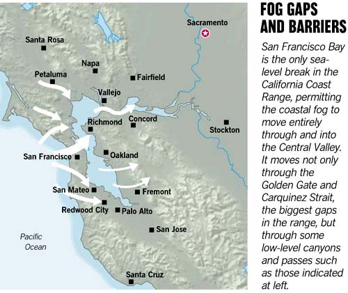
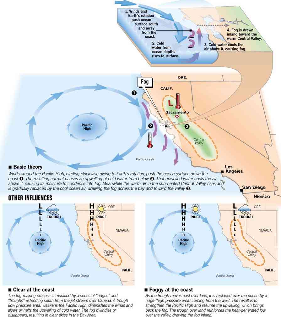
HOW BAY AREA FOG FORMSSummer fog is as characteristic of San Francisco as sourdough and cable cars. At the simplest level, it can be explained as the result of hot air in the Central Valley and cool ocean currents offshore. But scientists are learning that it is also influenced by more complex global weather forces. 1. Winds and Earth's rotation push ocean surface south and away from the coast. 2. Cold water from ocean depths rises to surface. 3. Cold water cools the air above it, causing fog. 4. Fog is drawn inland toward the warm Central Valley. -- Basic theory Winds around the Pacific High, circling clockwise owing to the Earth's rotation, push the ocean surface down the coast 1. The resulting current causes an upwelling of cold water from below 2. That upwelled water cools the air above it, causing its moisture to condense into fog. Meanwhile the warm air in the sun-heated Central Valley rises and is gradually replaced by the cool ocean air, drawing the fog across the bay and toward the valley 3. OTHER INFLUENCES-- Clear at the coast The fog-making process is modified by a series of ``ridges'' and ``troughs'' extending south from the jet stream over Canada. A trough (low pressure area) weakens the Pacific High, diminishes the winds and slows or halts the upwelling of cold water. The fog dwindles or disappears, resulting in clear skies in the Bay Area. --Foggy at the coast As the trough moves east over land, it is replaced
over the ocean by a ridge (high pressure area) coming from the
west. The result is to strengthen the Pacific High and resume
the upwelling, which brings back the fog. The trough over land
reinforces the heat-generated low over the valley, drawing the
fog inland.
HOW TO REACH USComments, questions and suggestions for The Chronicle's Science page are welcome. Reach us by e-mail at science@sfgate.com, by fax at (415) 896-1107 or in care of Science Page, San Francisco Chronicle, 901 Mission St., San Francisco, CA 94103. For updated science news throughout the week and links to science Web sites, go to sfgate.com/science/. |